Geologists To Survey Seven Sinkholes In Khon Kaen
Seven sinkholes have appeared in farmland near Ban Wang Charoen village in Khon Kaen's Phu Pha Man district, part of a decade-long subsidence problem in limestone terrain. Geologists will survey the area on August 5 to determine causes and
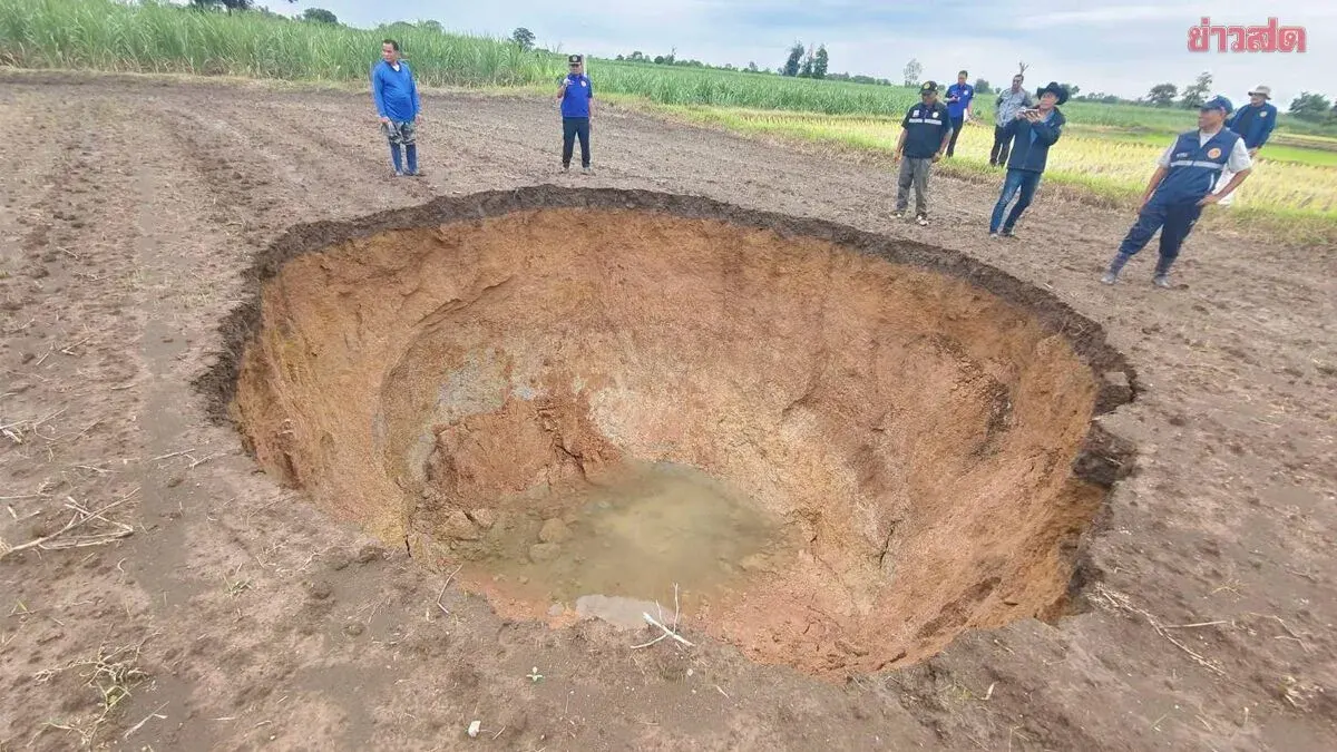
On August 4, in sugarcane and rice paddy areas west of Ban Wang Charoen village, Moo 2, Huai Mueang subdistrict, Phu Pha Man district, Khon Kaen province, social media posts revealed images of seven large sinkholes, causing alarm and widespread sharing of opinions.
Komphetch Krosing, chief of Huai Mueang subdistrict administration, stated that the ground collapses are not new but have been occurring for approximately 10 years since 2015 and continuing to the present. When the incidents first occurred, relevant agencies, particularly geologists, inspected the area and determined that the zone is limestone terrain susceptible to subsidence. Warning signs before collapse take various forms: some areas show slight settling, some create depressions, and some emit air gusts resembling boiling water before the ground gives way. This situation has alarmed local farmers and gardeners working the fields, as they cannot predict when the ground will collapse. However, no reports have surfaced of anyone falling into the holes or suffering injuries from the incidents. Residents can only take precautions themselves.
Over the past 10 years, authorities have coordinated with geologists and relevant agencies to investigate the causes, but still await answers from specialist agencies. Each time a collapse occurs, a nearby limestone mill brings crushed stone to fill the holes and help residents, but many refilled areas subside again shortly afterward. Some locations have experienced recurrence within just one year.
Huai Mueang subdistrict administration lacks sufficient capacity to address such a large-scale problem, so it coordinated with the limestone mill for assistance. The mill fills holes with crushed stone where they appear, but agricultural land and people's livelihoods are lost, creating hardship for residents. The next course of action is to coordinate with specialized geologists equipped with inspection tools to identify the cause and discuss comprehensive, sustainable solutions with multiple agencies.
Nunsil, 68, a landowner, revealed that she owns two agricultural plots. The first plot contains 3 rai of rice paddy with one collapsing hole that began subsiding on August 3 and had expanded significantly by the morning of August 4, accompanied by sounds of soil cracking. Her second plot spans 9 rai of sugarcane with five large sinkholes, which she fears to inspect for risk of falling in. After discovering the holes, she was shocked but still needed to complete harvesting for her livelihood.
Local residents believe the cause stems from limestone quarrying operations and groundwater extraction that weakened the soil, and are seeking assistance and compensation from relevant authorities, as the affected areas can no longer be farmed. Tomorrow, August 5, geological department officials will conduct another site inspection to identify the cause and discuss solutions with relevant agencies.