Heavy Rain Warning Issued for Khao Yai, Wang Nam Khiao
Suranaree University of Technology has issued a heavy‑rain warning for Pak Chong (Khao Yai) and Wang Nam Khiao districts from October 5‑8, 2026, highlighting risks of landslides, rockfalls, and flash floods. The alert, based on recent rainfall and geological assessments, notes that dangers may persist after the rain stops due to delayed‑effect slope failures. Authorities urge residents and tourists to remain vigilant and follow safety guidance.
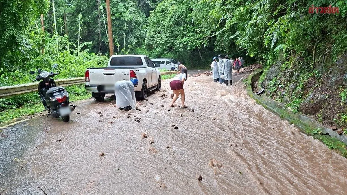
Suranaree University of Technology (SUT) in Nakhon Ratchasima warned residents and tourists in Pak Chong (Khao Yai) and Wang Nam Khiao districts to be alert for heavy rain from October 5–8, 2026, citing risks of landslides, rockfalls, and flash floods, as well as hidden dangers. On October 2, 2026, the university released disaster monitoring data on landslides, flash floods, and sudden inundation, outlining preparations for renewed rainfall accumulation and providing geological information that warns of slope failures, rockfalls, and flash‑flood hazards, including delayed‑effect risks that remain after rainfall ends. The warning was directed at the public and visitors in Pak Chong (Khao Yai) and Wang Nam Khiao districts. Dr. Satsasap Phakdimekh, a lecturer in Geo‑Engineering at the Faculty of Engineering, said that continuous heavy rain in Khao Yai National Park, Pak Chong, and the linked Wang Nam Khiao area at the end of September had caused flash floods that swept muddy water onto the road surface (see Figure 1). The reddish‑brown, turbulent flood shown in the images is an early warning sign indicating the washing away of residual soil layers on slopes. The muddy water condition shows that the topsoil has become saturated with water and lost its cohesion, leading to the risk of soil slides and rocks falling onto the road, especially where road cuts have high gradients. The likelihood of failure varies from place to place according to geological and topographic conditions. According to the Nakhon Ratchasima landslide‑susceptibility map from the Department of Mineral Resources (Figure 2), the at‑risk area around Pak Chong–Khao Yai falls into the category of soil derived from weathered volcanic rock, which is highly prone to landslides, particularly when road gradients exceed 30 degrees due to road‑cutting. In contrast, Wang Nam Khiao, characterised by steep sandstone cliffs of the ‘e‑to’ hill, is supported by a sedimentary rock unit, especially the sandstone of the Phra Vihar formation; residual soil there comes from weathered sandstone and sandy‑siltstone. A key trigger for failure in sedimentary rock is rainwater seeping into fractures; the sandstone of the Phra Vihar formation is relatively resistant to dissolution when immersed, but its strength declines through natural wet‑dry cycles. When these fractures encounter rainwater, wet‑dry cycling causes the cracks to expand, weakening the rock’s shear strength. If a slope is cut steeper than 45 degrees, the rock face is exposed to air and water, reducing friction and leading to rockfalls or landslides that develop from expanding cracks. The most critical hazard to monitor in both areas is the delayed‑effect danger of slope failure, as illustrated by a case study of more than twenty landslide sites on the Pharak‑Slad slope in Wang Nam Khiao in 2020 (Figure 3). The study showed that failures often do not occur on the day of peak rainfall but appear several days later, as rainwater slowly infiltrates the soil, building pore‑water pressure in voids and rock fractures, gradually reducing resistance until collapse happens. Thus, even after rain stops, the threat of rockfalls and landslides on steep cut slopes remains. Besides slopes, the mass of water flowing downstream also causes impacts